ESRGC Newsletter - Spring 2025

Eastern Shore Regional GIS Cooperative Newsletter
Salisbury University Campus

Welcome to the Spring 2025 Edition of the ESRGC Newsletter!

As the semester winds down and the days grow longer, the Eastern Shore Regional GIS Cooperative (ESRGC) is wrapping up another productive year. Spring brings with it new opportunities, and we’re excited to share what we’ve been up to. Our team has been hard at work finalizing a variety of projects, including several in partnership with departments across Salisbury University. We’ve also continued our outreach with regional municipalities, applying GIS tools to support smarter planning and decision-making throughout the Delmarva region. As part of our commitment to fostering the next generation of geospatial professionals, we continue to place SU students in paid GIS internships, offering valuable hands-on experience. Looking ahead, we’re thrilled to welcome local middle schoolers to Salisbury University's campus during our upcoming Future Mappers Summer Camp. Thank you to our incredible network of students, alumni, faculty, and partners who help make this work meaningful.

Project News

Future Mappers

Future Mappers Summer Camp

We’re excited to announce that Ryan Mello will be leading the Future Mappers Summer Camp, part of Salisbury University’s Summer Enrichment Academies.  Future Mappers is a STEAM (Science, Technology, Engineering, the Arts, and Mathematics) camp designed to spark curiosity and build skills in middle school students.  This immersive, hands-on program introduces campers to the power of mapping and geospatial technology through fun, real-world activities.
 
 Participants will use tablets and ArcGIS Field Maps to collect and analyze field data, fly drones to capture aerial imagery, and create interactive StoryMaps that combine geographic data with creative storytelling. These experiences not only foster creativity and critical thinking but also give students the opportunity to compete in Maryland's 2025 Student ArcGIS Online Competition, where they can earn recognition and prizes.  Camp attendees will also explore how Geographic Information Systems (GIS) are used to solve real-world challenges in areas like urban planning, environmental conservation, and disaster response. 
 
 Enrollment is now open, and spots are filling quickly!

  • Dates: Monday, June 23 - Friday, June 27, 2025
  • Grades: Middle School
  • Time: Half Day - 1-4 p.m.
  • Location: Salisbury University Campus
  • Lunch: Lunch NOT Provided
  • Cost: $275
  • Capacity: 16 Spots
 

Updating County Building Footprints with Deep Learning

The ESRGC is now using a pretrained deep learning model and the latest aerial imagery, captured in the spring of 2024 (insert a comma) to update county building footprint data. Esri's ArcGIS pretrained deep learning model for building footprint extraction was developed and trained on massive datasets to review aerial imagery, identify buildings in the imagery and capture the footprints of the buildings. By leveraging a pretrained deep learning model, the ESRGC is able to avoid the process of building and training models in-house and benefit from the significant reduction of hours required to manually digitize building footprints from imagery. Our team has completed the analysis of Caroline County's building footprints and is currently reviewing the spatial data output. As with all trained models, the data output must be reviewed for errors, which includes the identification of shipping containers as buildings. Other pretrained models from Esri that may be useful in our region include car detection, ship detection, pool detection and solar panel detection. Learn more about Esri's ArcGIS pretrained learning models here.
 
The pretrained deep learning model project is a GIS Circuit Rider project supported by the Mid-Shore Regional Council with funding from the Rural Maryland Council and Rural Maryland Prosperity Investment Funds (RMPIF). Learn more about the RMPIF supported GIS Circuit Rider program here.

Academic Dashboard

SU Academic Dashboard

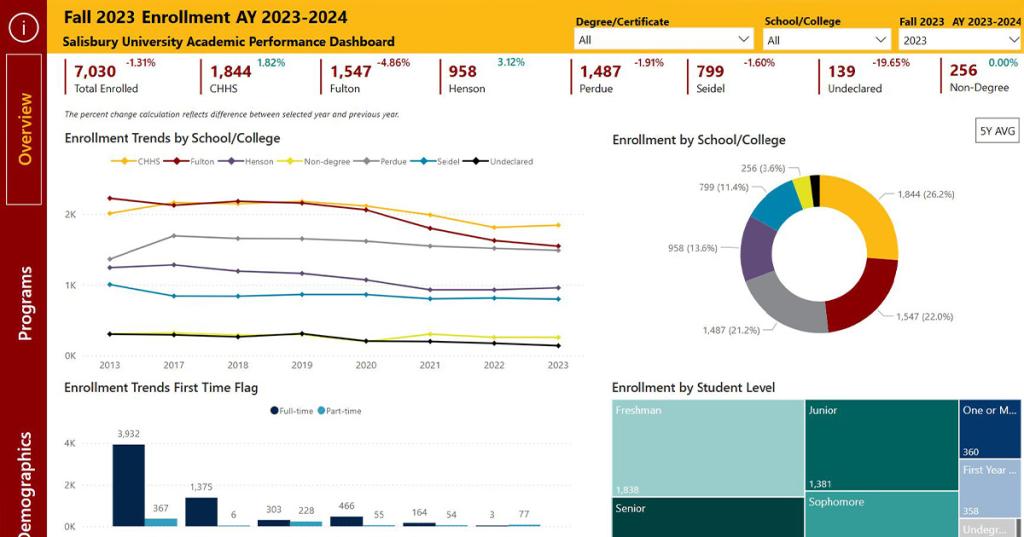
The ESRGC is proud to provide GIS and data visualization support to various departments at Salisbury University, including University Analysis, Reporting, and Assessment (UARA). In collaboration with UARA, we’ve developed three interactive institutional dashboards that visualize key metrics on enrollment, credit hours, and degrees awarded at Salisbury University.


 Each dashboard follows a consistent design and functionality framework while incorporating unique features tailored to the specific dataset. Users can explore the data by filtering across multiple dimensions, such as degree or certification type, school or college, academic program, and academic year. Interactive line charts throughout the dashboards make it easy to identify trends over time and understand percent changes at a glance.

 These dashboards—accessible through the Salisbury University website—serve as valuable tools for informing faculty, staff, and the public, supporting data-driven insights across campus.

Trail Mapping Image

ESRGC Supports Mapping of Glenda Chatham Clarke Arboretum

The ESRGC recently partnered with Salisbury University’s Horticulture Department to create a detailed campus map for the newly dedicated Glenda Chatham Clarke Arboretum. Designed to highlight the arboretum’s key features and its integration within the broader campus landscape, the map will be featured on a large outdoor display near the Guerrieri Student Union. This marker not only celebrates the natural beauty of the arboretum but also invites visitors to embark on a self-guided walking tour of the campus, encouraging deeper exploration and appreciation of the university’s green spaces. 

Celebrating Milestones!

Please join us in recognizing three of our team members for their incredible dedication and service to the ESRGC and Salisbury University:


  • Casey Wood5 years
  • Mary Buffington 15 years
  • Lauren McDermott20 years
 

ESRGC Spotlight: Garrett Ackerman

Connor Lewandowski

Our Spring 2025 Spotlight is current SU student and ESRGC intern, Garrett Ackerman.

Complete ESRGC Spotlight

The ESRGC at Salisbury University regularly features a current or former intern for our Intern Spotlight. 

Read More

Where to Find the ESRGC this Summer

  • Maryland Municipal League (MML) Summer Conference & Expo: 06/23 – 06/24/2025
  • Towson University GIS Conference (TUgis): 08/06 – 08/07/2025
  • Maryland Association of Counties (MACo) Summer Conference: 08/14 – 08/15/2025
 
What is GIS?

GIS stands for Geographic Information Systems (or Science). It’s a tool used to make maps and explore information about different places. GIS shows us where things are and what’s going on there. GIS assists with data-driven decisions, like choosing the best place for a new school, planning for flood risks, or understanding changes in the environment. By turning data into maps and visuals, GIS helps us spot patterns, solve problems, and plan for the future.

ESRGC Logo

Where to find ESRGC

facebook     linkedin     youtube

esrgc.org

Give to ESRGC

Salisbury University Logo

A copy of the current financial statement of the Salisbury University Foundation, Inc. is available by writing 1308 Camden Avenue, Salisbury MD 21801 or on its website, salisbury.edu/foundation. Documents and information submitted under the Maryland Solicitations Act are also available, for the cost of postage and copies, from the Maryland Secretary of State, State House, Annapolis MD 21401, 410-974-5534.

SU is an Equal Opportunity/AA/Title IX university and provides reasonable accommodation given sufficient notice to the University office or staff sponsoring the event or program. For more information regarding SU’s policies and procedures, please visit salisbury.edu/equity.

Can’t View this email? View it Online

 1101 Camden Avenue Salisbury, MD 21801 | 410-543-6000

Click here to safely unsubscribe