ESRGC Newsletter - Fall 2025

Eastern Shore Regional GIS Cooperative Newsletter
Holloway Hall Photo taken with a drone

Welcome to the Fall 2025 Edition of the ESRGC Newsletter!

In this edition, preview our Maryland-focused coastal flood visualization, explore Salisbury University’s Centennial Alumni Spotlight Map, and see how we’re helping partners tell richer stories with ArcGIS StoryMaps. We’re also rolling out new resources for the agricultural community, celebrating team milestones, and spotlighting our intern talent.

Project News

Flood Map

Visualizing Current and Future Flooding in Coastal Maryland

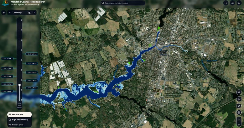
Coastal flooding is an increasing hazard for Maryland's coastal regions. In an effort to provide coastal communities and decision-makers equal access to high-quality and high-resolution data, the ESRGC recently partnered with the Maryland Department of Natural Resources and University of Maryland SeaGrant to develop a flood visualization tool designed for Maryland's unique vulnerability to flooding and sea level change. As technical partners on this project, the ESRGC provided sea level rise projection and data engineering expertise to guide project partners in decision making and focus group question development. The ESRGC also interviewed nine subject matter experts and developers of other flood visualization tools to learn about the needs of users and successes/challenges other developers experienced over time. One of the biggest takeaways from these discussions focused on the sustainability of the tool, mainly, what elements could be implemented now to avoid major rebuilds in the future. The ESRGC strongly advocated for the Maryland Coastal Flood Explorer to be a Maryland tool at its core, using sea level rise projections specific to Maryland, local LiDAR-derived products for depth grid development, and built-in functionality to add data layers from Maryland iMap. The sea level rise predictions developed and last released in 2023 by the University of Maryland Center for Environmental Science are local and current predictions specific to Maryland.  The ESRGC designed and built the web interface using modern web standards, rigorously testing functionality and design to deliver a focused, reliable flood-visualization experience. The tool offers local planners access to data to support development and updates to hazard mitigation plans, comprehensive plans, and nuisance flood plans, while Maryland residents may explore the tool to better understand current and predicted future flooding in their community. Explore Maryland’s sea level change, high-tide flooding, and historic flooding at www.mdfloodexplorer.org.

SU Alumni Map

SU Centennial Alumni Spotlight Map

The ESRGC teamed up with the Salisbury University Alumni House to launch a new interactive map celebrating SU’s Centennial—building on our U.S., International, and GOLD (Gulls of the Last Decade) maps. Explore where Sea Gulls live, work, and lead, and dive into our featured profiles and stories that highlight the people behind the pins and connect generations of Gulls. Use the filter by major to find fellow grads and discover their stories. Explore the Centennial Spotlight Map

Nabb Center StoryMap Training

The ESRGC hosted the staff of the Edward H. Nabb Research Center for Delmarva History and Culture at Salisbury University for an ArcGIS StoryMaps training in October. This training focused on how StoryMaps may be used to tell Delmarva's history using data, maps, embedded content, and multimedia. StoryMaps are a form of digital storytelling, connecting place and narrative in an interactive product. Often, the hardest part of StoryMap development is finding content to support the story. As collectors and curators of Delmarva history, the Nabb Center has many stories to tell - we're excited to see how they incorporate StoryMaps in their future work! Interested in learning more? Contact the ESRGC to learn about how we can support your SU department with GIS expertise!

Agriculture Census Dashboard

Developed by the ESRGC, in collaboration with the Mid-Shore Regional Council and the Tri-County Council for the Lower Eastern Shore of Maryland, the Agricultural Census Dashboard delivers a dynamic and accessible overview of key agricultural indicators across the state of Maryland. Interactive maps and visualizations bring Maryland’s agricultural story to life, making complex data approachable and actionable. Whether you're evaluating the economic impact of farming, supporting agricultural planning, or analyzing trends in crop production and farm demographics over time, this dashboard serves as a vital resource for data-driven decision-making in the agricultural sector. 

Maryland Agriculture Reporting Tool (MART)

Maryland Agriculture Reporting Tool (MART)

The ESRGC and the University of Maryland Extension, in collaboration with state and local partners, are excited to introduce the Maryland Agriculture Reporting Tool (MART).  This free, secure, online resource is designed to simplify recordkeeping, enhance decision-making, and assist Maryland farm producers with state and federal reporting requirements. MART can be accessed at https://mdagreporting.org/

ESRGC News

ESRGC Named Latest GISCI Endorsing Employer

ESRGC Named Latest GISCI Endorsing Employer

The ESRGC has long supported its staff in the pursuit of excellence in the geospatial profession. As a reflection of this support and our incredibly dedicated staff, the ESRGC was recently recognized for our outstanding commitment to advancing professional standards and supporting continued development in the geospatial industry.

Read More

ESRGC Celebrations

ESRGC Baby Announcements

  • Tim Lanzi and family welcomed Baby Parker.
  • Ryan Mello and family welcomed Baby Jane.
 

Please join us in congratulating both families!

SU Staff Spotlight

Recognizing campus colleagues who quietly keep ESRGC moving.


The ESRGC would like to recognize Stefanie Barfield, Payroll Processing Associate, for her outstanding professionalism and dedication to service. During a recent, complex audit, Stefanie   demonstrated exceptional responsiveness and went above and beyond to provide the information and support needed. Her commitment to excellence and attention to detail were instrumental in ensuring a successful outcome.


Thank you, Stefanie, for your hard work and exemplary service!     

ESRGC Intern Spotlight

Connor Lewandowski

Our Fall 2025 Spotlight is current SU student and ESRGC intern, Jack Carpenter.

Read More

Adjunct Faculty Offerings

This semester, our own Erin Silva is teaching Geog 630: GIS and Public Administration.  This course is within the Master of Science in Geographic Information Systems Management (GISM) program at Salisbury University.  The course examines practical approaches for incorporating GIS technology into a public administration setting. Students discuss implementation strategies, cost-benefit analyses, and strategies for overcoming technical and organizational boundaries.


This semester, our own Anastassiya Suprunova is teaching GEOG 320: Cartographic Visualization GIS. This course covers design principles and techniques for creating maps with modern mapping tools, including ArcGIS Pro. Anastassiya hopes that with this the students will be introduced to interactive geo-visualization and (geo)visual analytics.

What is GIS?

GIS stands for Geographic Information Systems (or Science). It’s a tool used to make maps and explore information about different places. GIS shows us where things are and what’s going on there. GIS assists with data-driven decisions, like choosing the best place for a new school, planning for flood risks, or understanding changes in the environment. By turning data into maps and visuals, GIS helps us spot patterns, solve problems, and plan for the future.

ESRGC Logo

Where to find ESRGC

facebook     linkedin     youtube

esrgc.org

Give to ESRGC

Salisbury University Logo

A copy of the current financial statement of the Salisbury University Foundation, Inc. is available by writing 1308 Camden Avenue, Salisbury MD 21801 or on its website, salisbury.edu/foundation. Documents and information submitted under the Maryland Solicitations Act are also available, for the cost of postage and copies, from the Maryland Secretary of State, State House, Annapolis MD 21401, 410-974-5534.

SU is an Equal Opportunity/AA/Title IX university and provides reasonable accommodation given sufficient notice to the University office or staff sponsoring the event or program. For more information regarding SU’s policies and procedures, please visit salisbury.edu/equity.

Can’t View this email? View it Online

 1101 Camden Avenue Salisbury, MD 21801 | 410-543-6000

Click here to safely unsubscribe